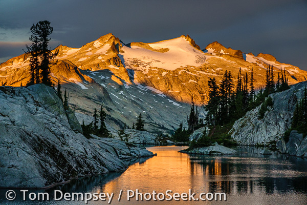
Mount Shuksan reflects in Picture Lake, WashingtonPage 0:  Highlights of Washington State, USA

Photographs Copyright 1982-2008 by Tom Dempsey. Custom Print Prices. 
I last updated this page on March 5, 2010. Send comments to: tom@photoseek.com

Back to Photoseek home. | Tom's Portfolio of Published Images | My Fine Art Gallery | Buy My Images | Photo Equipment Advice
| About This Web Site

Right: Mount Shuksan (in North Cascades National Park) reflects in Highwood Lake, located in Mount Baker-Snoqualmie National Forest, Washington.

PhotoseekIndex to Washington: map ~ 0 ~ 1 ~ 2 ~ 3 ~ 4 ~ 5 ~ 6 ~ 7

This page 0 shows my favorite images from seven Washington pages 1 , 2 , 3 , 4 , 5 , 6 , 7 .  Click any image or link to see more from that area:


Left
: Spectacular fireworks explode over Gasworks Park, witnessed by a large audience of boats in Union Bay, at dusk July 4, 2007 in Seattle.


Below right: Ripples on the water surface distorts this view of an orange and red sea anemone at the Seattle Aquarium, Washington.0803AQU-16.jpg


Above: I captured this view of downtown Seattle, the Space Needle, Puget Sound and the Olympic Mountains at sunset, on July 4, 2007. (Panorama stitched from 4 images; photographed from the 33rd floor of First Hill Plaza, 1301 Spring Street, Seattle.)

Washington: Spray Park, in Mt. Rainier NP
Left: A landscape of avalanche lilies (Erythronium) & buttercups in Spray Park, Mount Rainier National Park. [Published in 1996.]


Below: The Spokane, part of the Washington State Ferry system, cruises in Puget Sound from Edmonds to Kingston in sight of Mount Baker (10,775 feet elevation), Washington.

Washington Map

Washington-map.jpg
1991 partial solar eclipse over Puget Sound, seen from Seattle.
Left: A partial solar eclipse sets over Puget Sound in 1991, seen from Sunset Hill Park, in the Ballard neighborhood of Seattle. [Published on the cover of The Mountaineer, September 1996, the monthly magazine of The Mountaineers club. Winner of Best Scenic in their 1996 cover photo contest.]

Natural History of Washington

The state of Washington is more ecologically and scenically diverse than any state in the Lower 48 contiguous United States, due to many factors. In altitude, the land varies from sea level to 14,411 feet at the summit of Mount Rainier, an awesome active volcano covered in glaciers. The Carbon Glacier of Mount Rainier flows to a lower altitude than any other glacier in the Lower 48 states. A huge glacier actually covered Seattle 3,000 feet deep in ice only 15,000 years ago, gouging the scenic fjord of present-day Puget Sound.
    Washington's latitude lies in a transitional belt between sub-Arctic northern forests and warmer drier regions. Moist temperate air masses sweep onto the west coast and hit the spectacular Olympic and Cascade mountain ranges, dumping heavy rain on the southwestward (windward) slopes, creating dense temperate rainforest. The mountains wring the air dry, creating extensive rain shadows to their east and northeast, such as in the sunny San Juan Islands, and in the desert lands of Eastern Washington, irrigated by the mighty Columbia River.
    Washington's soil varies from shallow forest layers to windblown sand and agriculturally rich loess with basaltic outcroppings. Rocks vary widely, with tectonic uplifts of andesite, argillite, or granite in some ranges. These and other factors have created a tremendous variety of scenery, native plants and wildflowers in Washington, a great state to explore.


Below: Ground cover glows red in autumn in Mount Rainier National Park. (This image available for purchase, with or without a person in the frame.)
02RAI-01-13-MtRainier.jpg
San Juan Islands, Washington
Left: The Lime Kiln Lighthouse first shone in 1919 from the present tower. The red-orange bark of a
Pacific Madrone (or Madrona) tree peels characteristically at Lime Kiln Point State Park, on San Juan Island, Washington, USA.


Below: A white Avalanche Lily (Erythronium) grows by a yellow Glacier Lily on Tolmie Peak, Mount Rainier National Park.
05RAI_064-Avalanche+Glacier-Lily.jpg
0607BER_0234-Rainier-Lupine.jpg
Left:
Afternoon sun hits Mount Rainier and lupines near Sunrise Visitor Center.


Below:
A side stream foams past Big Quilcene Trail #833.1 below Marmot Pass, in Buckhorn Wilderness, Washington.

Below: Panorama of Mount Baker (summit 10,775 feet, upper right) and Baker Lake (far left) from Artist Point (stitched from 4 images):
Mount Baker, WA

Below: Western Anemone seed heads blowing in the wind, in Goat Rocks Wilderness Area.
0607GOA_0915-Anemone-heads.jpg

Skagit Valley image from photoseek.com

Left: a yellow tulip is tinged with red-orange in the Skagit River Delta, Washington.

Seattle, Washington, USA: summer sunset

Above: Summer sunset reflects in Seattle buildings. Photographed on the day of my first date (June 26, 1995) with Carol, and we married two years later!  [See my page of published images ]

Below right: Exterior of 2004 Seattle Public Library,
designed by Dutch architect Rem Koolhaas, finished in 2004.
Seattle Public Library, new in 2004.


Above: Three Tiger Lily (also known as Columbia Lily, Lilium columbianum) flowers on Granite Mountain.

04SNO-0065-66pan-Icicles.jpgLeft: Icicles at Alpental, Snoqualmie Pass, Interstate 90.Left: Icicles at Alpental, Snoqualmie Pass, Interstate 90.
05TWI_12-13pan-Twin-Falls-OllalieSP.jpg
Above right: Upper Falls in Twin Falls Natural Area, Ollalie State Park, makes a short and rewarding hike near Interstate 90 Exit #34. (Pictures of Lower Twin Falls also available upon request.)

Skagit Valley image from photoseek.com
Left: Snow geese fill the sky in a farmer's field on Fir Island in the Skagit River Delta.

Below: Kendall Peak (5675 feet elevation) in winter, near Snoqualmie Pass on Interstate 90.
05KEN-0023-Kendall-Peak.jpg

Below left: Five-Finger Fern (or Western Maidenhair, Adiatnum pedatum aleuticum), in Twin Falls Natural Area, Ollalie State Park, in the Cascade foothills of western Washington, off of Interstate 90.
05TWI_23-Five-Finger-Fern.jpg

Below right: Stone and sand Japanese garden, Bloedel Reserve, Bainbridge Island, Washington..
05BLO_55-Boedel-Reserve.jpg
05BLO_41-maple-leaves.jpg
Left: looking up into backlit
Japanese maple leaves. Bloedel Reserve, Bainbridge Island, October 19, 2005.

   
Below right: Hydrangea in the Bloedel Reserve, Bainbridge Island, October 19, 2005.
05BLO_28-hydrangea.jpg

Below: mossy branches of a Japanese maple tree, Bloedel Reserve, Bainbridge Island, October 19, 2005.
05BLO_25-JapaneseMaple.jpg

Below: Yellow larch forest in the fall, beneath Little Annapurna, Enchantment Lakes, Alpines Lakes Wilderness Area, Washington.
85ENC-07-09-Enchantments.jpg

05RAC_08-Dogwood-Flower.jpg
Left: Dogwood flowers (Latin name Cornus), Alpine Lakes Wilderness Area.

Below: Snowy branches near Alpental, Snoqualmie Pass.
04SNO-0029-SnowyBranches.jpg
Below: Mountain Goat and Mount Daniel, near Robin Lake in Alpine Lakes Wilderness Area, Washington.
88ROB-02-32-Goat_MtDaniel.jpg

05PRA_26-Many-flowered-Indian-pipe.jpg
Left: This plant is a species of Pinesap (monotropa hypopithys L.), which has a cluster of 3-10 nodding pale yellow, tan, or sometime reddish flowers on a single stem. This plant is saprophytic and doesn't use chlorophyll.  Alpine Lakes Wilderness Area.

Pine-drops grow about two feet high (Scientific name: Pterospora, in the Heath Family), and are a saprophytic plant that doesn't use chlorophyll.  Alpine Lakes Wilderness Area.
05PRA_39-Pine-drops.jpg

05RAC_33-Monkshood-Flower.jpg
Left: The Columbia Monkshood flower, Latin name Aconitum (Buttercup Family), with a fern in the background. Alpine Lakes Wilderness Area.


Below: A camouflaged Crab Spider (Family Thomisidae) kills a bee in this thistle flower. Crab Spiders can change their coloration to match the flower within 24 hours. They are widespread in Washington and other states. On the trail to Rachel Lake in Alpine Lakes Wilderness Area.
05RAC_41-Spider-kills-bee-thistle.jpg
Below: Granite Mountain Lookout (5629 feet elevation), from where you can view Rainier 42 miles to the south. Located in Alpine Lakes Wilderness Area, Granite Mountain is a hike of 8 miles with 3800 feet elevation gain, accessed from Exit 47 of Interstate 90.
05GRA_28-30pan-Granite-Mt.jpg

04WA9-0018-Coral-Hydnum-closeup.jpg
Left: Closeup section of a Coral Hydnum mushroom (Hericium coralloides), Alpine Lakes Wilderness Area, Wenatchee National Forest.


Below right: Two Admirable Boletus Mushrooms (Boletus mirabilis), each about five inches across, in Alpine Lakes Wilderness Area, Wenatchee National Forest.
04WA9-0010-Admirable-Boletus.jpg

04POL-0046-Mushrooms.jpg
Left: Chanterelle (Cantharellus) mushrooms, Alpine Lakes Wilderness Area, Wenatchee National Forest.

Below: Oyster mushrooms, Alpine Lakes Wilderness Area, Wenatchee National Forest.
04WA9-0036-Oyster-Mushrooms.jpg

Below: Beautiful backlit orange mushrooms (maybe a false chanterelle / Clitocybe aurantiaca?), Alpine Lakes Wilderness Area, Wenatchee National Forest.

04POL-0005-OrangeMushrooms.jpg


Below left:
Foggy Lake, Gothic Basin, a hike from Barlow Pass on the Mountain Loop Highway.
05GOT_10-Foggy-Lake.jpg
0607GOA_0831-Mt-Adams.jpg

Above: Mount Adams is seen from a day hike in Goat Rocks Wilderness Area.

0607LAV_0204-PurpleHaze.jpg
Above: Yellow sage and purple lavender on Purple Haze Lavender Farm, in the town of Sequim. The Sequim Lavender Festival is held yearly in mid-July in the town of Sequim, "The Lavender Capital of North America", on the Olympic Peninsula, Washington.

Below: Old farm equipment rusts in a field of lavender, on Cedarbrook Lavender & Herb Farm, Sequim.
0607LAV_0150-Cedarbrook.jpg

Mount Olympus, seen from the High Divide Trail, in Washington.
Above: Mount Olympus, seen from the High Divide Trail in Washington. In 1981, UNESCO listed Olympic National Park a World Heritage Area, and described it as follows: "A great variety of landscapes and ecosystems can be found there, with a great wealth of marine life along its rocky coast, forests of giant conifers in the valleys where huge herds of wapiti [large deer] roam, and craggy peaks overhanging some sixty active glaciers."


Above: A wild native rhododendron flower buds in Buckhorn Wilderness, in Olympic National Forest, on the Mount Townsend trail #839 in late June.

Twin Sisters Mountain, Washington
Above: Twin Sisters Mountain can be seen from the Railroad Grade on Mount Baker, Mount Baker-Snoqualmie National Forest.

Tiger Lily, Church Mountain, Mt Baker-Snoqualmie National Forest, Washington
Left: A Tiger Lily (or Columbia Lily) grows on Church Mountain in mid-July, with Mt. Baker as a backdrop. Mt Baker-Snoqualmie National Forest.

Below:
Hikers descend the "Railroad Grade", a lateral moraine of the Easton Glacier, looking into Mount Baker Wilderness.
Hiking the Railroad Grade, Mount Baker National Recreation Area
Below: Pretty blue butterflies rest on Church Mountain.
04WA-0058-blue-butterflies.jpg

05SAU_17-Glacier-Lily.jpg
Left: A Glacier Lily blooms on Sauk Mountain, near the town of Concrete. Mount Baker-Snoqualmie National Forest.

Below: An old ship docks in Anacortes, with Mount Baker (10,775 feet) rising in the distance.
05WHI-20099-Ship-MtBaker.jpg
   
Below: An old dock gathers barnacles in Anacortes.

05WHI-20108-OldDock-Anacortes.jpg
02GRA-03-28-RainyPass-SR20.jpg
Above: We hike the Maple Pass Loop Trail above the North Cascades Highway (Washington State Route 20) at Rainy Pass, Okanagon National Forest.

05WHI-10096-DeceptionPassBridgePattern.jpg
Left: Girders form a pattern on Deception Pass Bridge between
Whidbey Island and Fidalgo Island.


    Below right: Lichen covers old growth trees in Deception Pass State Park, Whidbey Island.
05WHI-10090-LichenTrees.jpg
Admiralty Head Lighthouse, Fort Casey State Park, Whidbey Island, Washington
Left: Admiralty Head Lighthouse was built in 1890 to help guide ships into Puget Sound, but became obsolete in 1927 when its lantern was removed. Fort Casey State Park is part of Ebey's Landing National Historical Reserve, Whidbey Island.


Below: Pioneers built Crockett Blockhouse in 1855 for protection from Indians, then built the barn in more stable times. Ebey's Landing National Historical Reserve, Whidbey Island.05WHI-20149-CrockettBlockhouse.jpg
Below: Tugboats guide a log raft through Deception Pass fog. A native madrona tree blooms on the left, on Whidbey Island.
05WHI-10098-DeceptionPassLogsMadrona.jpg
05WHI-10014-MeerkerkGardensRhodis.jpg
Left: Spectacular hybrid rhododendrons bloom in Meerkerk Gardens, Whidbey Island (April 27, 2005).

Below: A Great Blue Heron stands patiently on one leg in the forest on Fidalgo Island, in Deception Pass State Park.
05WHI-20044-GreatBlueHeron.jpg
0609SAH_49-57p-Doubtful-L.jpg
Above: Doubtful Lake and the Stehekin Valley, as seen from Sahale Arm, in North Cascades National Park, Washington (Panorama stitched from 9 images).

The above Highlights are taken from Washington pages 1 , 2 , 3 , 4 , 5 , 6 , 7
(Click any image, link or page to see more from that area)

Page 0:  Highlights of Washington State, USA


Washington Guidebooks: I recommend any of following books from Amazon.com for hikers and bicyclists:


Index to Washington (to top of this page): map ~ 0 ~ 1 ~ 2 ~ 3 ~ 4 ~ 5 ~ 6 ~ 7

Photoseek
Copyright 1982-2008 by Tom Dempsey. Photographs may not be copied without permission.

Back to Photoseek home. | Tom's Portfolio of Published Images | My Fine Art Gallery | Buy My Images | The Best Travel Cameras | About This Web Site