From July 13–August 3, 2023, I reveled in a solo hiking trip by car in GERMANY’s Bavaria, AUSTRIA’s states of Tyrol and Salzburg, and ITALY’s Dolomites mountains near Cortina d’Ampezzo. Flying into Munich puts you within a 2- to 3-hour drive of the Eastern Alps. Photo highlights below are gleaned from Tom’s full trip portfolio, “2023 Jul: Europe: Bavaria; Tyrol; Salzburg; Dolomites” (reached by clicking any image below) — my seventh journey to the Alps.
Table of Contents:
Part A: Germany’s Bavaria ⇔ Austria’s Tyrol | Maps 1 & 2
Part B: Ampezzo & Sesto Dolomites, Italy | Map 3
Part C: Austria’s Tyrol > Germany’s Bavaria | Map 4
Passing back and forth between Germany, Austria, and Italy is a breeze, thanks to the Schengen Area. They also conveniently share the euro currency. The borders are almost unnoticeable, except for signs changing languages and styles. I was awestruck by the tidy historic towns, super-smooth roads, good public restrooms, and lack of litter in Austria and Germany. Starting March 31st, 2024, Bulgaria and Romania officially joined the Schengen Area, expanding the participating countries to 29 — the world’s largest visa-free zone — wherein internal borders have been abolished to allow the free and unrestricted movement of people, as reported by SchengenVisaInfo. Such a high level of cooperation is both an inspiration and aspiration.
Part A: Germany’s Bavaria ⇔ Austria’s Tyrol
July 14, above: Nestled under Zugspitze (Germany’s highest peak), the attractive small-town retreat of Ehrwald in Austria was Tom’s home base for exploring Germany’s Bavaria and Austria’s Tyrol for six nights. Three more nights were in the cooler heights of Wattenberg village, just east of Innsbruck.
Map 1 of 4: From Munich Airport to Ehrwald, Austria, including some initial sights visited by Tom in Germany (waypoints: Garmisch-Partenkirchen, Kreuzeckbahn cable car, Eibsee, St. Coloman’s Church, Hohenschwangau Castle, and Neuschwanstein Castle) and in Austria (Ehrwald cable car, Ehrenberg Castle, and Die Eng Nature Hotel trailhead at Großen Ahornboden in Karwendel Nature Park).

July 15, above: The Ehrwalder Almbahn cable car above Ehrwald reaches the trailhead for popular Seebensee.
Below: I ascended further to Coburger Hut and around Drachensee (9.5 miles round trip with 2270 feet gain). On the far right is the peak of Ehrwalder Sonnenspitze, in the Mieming Chain of Northern Limestone Alps.
July 16: While waiting for clouds to clear, I walked the mildly interesting Leutasch Gorge, a family-friendly metal boardwalk high above a stream in Austria.

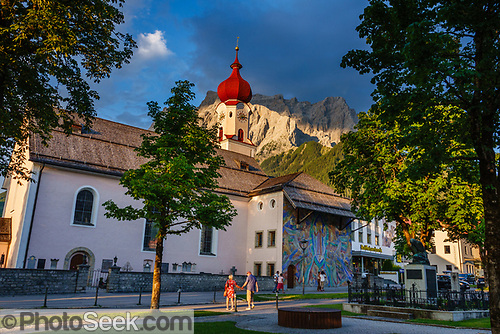
Above: Zugspitze (2,962 meters)—highest peak in Germany—rises above Garmisch-Partenkirchen, a skiing and hiking resort in Germany. I admired the lüftlmalerei (“airy paintings” or outdoor murals) along Ludwigstraße. Garmisch-Partenkirchen formed when two towns united in 1935. Lifts reach Zugspitze’s summit from both Germany (in Grainau) and Austria (in Ehrwald).

July 17, above: See Wildspitze (the second highest peak in Austria) from Café 3440 — a thrilling viewpoint above Mittelberg in the Pitz Valley, in the Ötztal Alps. In the first departure of the morning, take the Glacier Express funicular then board the Wildspitzbahn cable car to reach Café 3440. Steps lead up to a stunning observation deck. After admiring the view, descend to Kristall Glacier Restaurant at Gletscherexpress top station, where you can wander to Chapel of the White Light (0.2 miles round trip) and/or hike to Mittagskogel:
Below: Starting from Kristall Glacier Restaurant, I ascended a steep, rocky trail to the top of Mittagskogel for this view of the remote valley of Pitztal (2.2 miles with 1060 feet gain & loss round trip on a lollipop-shaped loop). The required rock-hopping didn’t deter some intrepid families.


July 18, above: In early morning, I walked briskly for a few miles to watch sunrise along the north side of Germany’s pretty Eibsee, a lake at the foot of Zugspitze near Grainau. Driving back around behind Zugspitze’s northeast ridge (on left side of photo) reached Kreuzeckbahn cable car base station to catch the morning’s first ride up to start an epic hike, as follows:
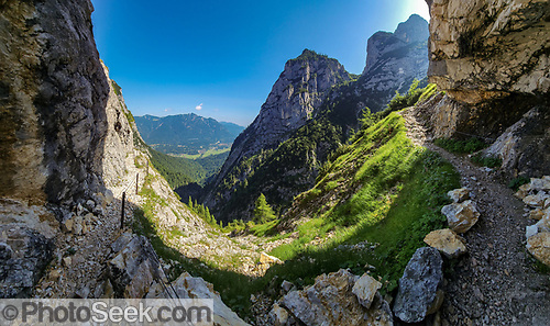
Above: From Garmisch-Partenkirchen in Germany, I rode Kreuzeckbahn cable car to begin an exciting ledge trail down into the Valley of Hell (Höllental) and its fun Gorge — Höllentalklamm, cradled within Zugspitze mountain.
Below: Wedged boulders hang above the Höllentalklamm (Valley of Hell Gorge), one of the greatest natural wonders in Bavaria. Many people hike Höllentalklamm directly from Hammersbach hamlet in Grainau (7.1 miles round trip, with 2800 feet gain and loss). But a more panoramic route starts from atop Kreuzeckbahn cable car and adds a thrilling ledge trail into the Valley of Hell cirque within Zugspitze (a circuit of 8.7 miles with 760 feet up and 3470 feet down, including Schwarzenkopf peak). Along with hundreds of others, I clambered through the scenic slot canyon for an exciting kilometer of drippy tunnels, ledges, stairs, and bridges built 1902–1905. The typical afternoon thunderstorms cooled the descent back to my rental car, which I drove 25 minutes back to Ehrwald in Austria.

More details for hiking Höllentalklamm: In Garmisch-Partenkirchen, follow signs to Kreuzeckbahn cable car, pay for parking, then ride it (don’t take the adjacent Alpspitzbahn). Walk to Hupfleitenjoch saddle. Optionally ascend a steep side trail to Schwarzenkopf peak to extend the trail’s views into a 360-degree panorama (adds 200 feet gain, 0.4 miles round trip). From Hupfleitenjoch, switchback on ledges down into the impressive Höllental, passing unmanaged huts at Knappenhäusern. More ledges descend to Höllentalangerhütte, a mountain hut with good lunch and impressive views of the Wetterstein mountains. Further below, hikers enter the top of the Höllental Gorge. Follow signs to Hammersbach über Klamm and to Höllentalklamm. When given a choice, pick the open-air path to see more of the tumbling stream, instead of taking the tight tunnels. Cross the Eiserne Brücke footbridge. Pay a fee upon exiting the gorge. Walk by Höllentaleingangshütte and wind down to Hammersbach village. Follow signs back to Kreuzeckbahn valley station.

July 19, above: One of my favorite places in Austria was Großer Ahornboden at Eng Alm in Upper Riss Valley (Hinterisstal), within Karwendel Nature Park. At Großer Ahornboden, historic maple trees are preserved in idyllic green pastures under shear rock walls carved by Ice Age glaciers. Think Yosemite, but without the crowds! Orphaned by national borders and Alpen ridges, this remote valley can only be reached from the Austrian mainland via German roads. To get here, I drove 90 minutes from Ehrwald in Austria via Garmisch-Partenkirchen in Germany and the narrow Mautstraße Wallgau-Vorderriß toll road through German wildlands. The entrance fee for Karwendel Nature Park covers all parking, including the trailhead lot at Die Eng Nature Hotel.
Below: Through idyllic pastures under craggy cliffs, I hiked from Eng Alm to Falkenhütte and back, on Austria’s Via Alpina Red Trail (continuous with the Swiss Via Alpina). Falken Hut (external link) has been run by the same family for 3 generations. The outing ended with afternoon showers which are typical in July here. Alps temperatures in July encouraged hiking in shorts all day.


July 20, above: In Germany, I toured the ornate inside of Hohenschwangau Castle, the hunting lodge where King Ludwig II of Bavaria was raised.
Below: On the adjacent hill, King Ludwig II of Bavaria began building Neuschwanstein Castle in 1869 over ruins of a medieval castle, but never finished. He lived there only 2 years, until his mysterious death in 1886. This palace inspired Walt Disney to build Sleeping Beauty Castle, opened in 1955 in California’s Disneyland. Inside, I toured rooms of exquisite decoration, including: a bedroom dedicated to composer Richard Wagner; an historical Ottoman-themed room; and a cave grotto complete with artificial stalactites & flowstone. Growing up watching The Wonderful World of Disney on 1960s TV, my inner child was touched.

The History of Bavaria in a nutshell: By the first century BC, the Romans subdued local Celts to create the provinces of Raetia and Noricum. Later, Bavaria began as a stem duchy in the 500s. The Holy Roman Empire absorbed it as an independent kingdom around 1000 AD. After World War II in 1945, the new Federal Republic of Germany included it as a Bundesland comprising a fifth of the country’s land area, making it Germany’s largest state.

Above: Nearby in Reutte, Austria, two cable cars and the lofty Highline179 footbridge aid visitors to see gothic Ehrenberg Castle, built in 1290 in Tyrol. Buying tickets to all three options saves hours of walking time:
- The inclined elevator I “Ehrenberg Liner” climbs 110m to the Ehrenberg Castle ruins, the free Hornwerk exhibition and Highline179.
- The inclined elevator II “Top Liner” (opened March 2023) reaches the highest point, the baroque Schlosskopf Fortress.
- Built in 2014, the record-setting 406-meter-long Highline179 connects Ehrenberg Castle ruins with Fort Claudia. (In 2017, the Highline179 was demoted to world’s second longest hanging bridge for pedestrians by the first longest — the Charles Kuonen Bridge, suspended 494 meters or 1,620 feet long above Grabengufer ravine near Randa, Switzerland.)
I drove past Innsbruck to an apartment in a country home above Wattens along the Inn River valley in Austria (downstream of Switzerland’s Engadine region, which Carol and I visited in 2005).

July 22, above and below: From Schlegeisspeicher reservoir reached by toll road in the Ziller Valley, I hiked to Olperer Hut, where this swing bridge makes a popular photo op (4 miles round trip with 2000 feet gain). A footrace staged that day circumvented the bridge.


July 23, above: From Obergurgl in Ötztal valley, Austria, I rode the HoheMutbahn cable car stages I and II to reach the scenic ridge of Hohe Mut Alm (8704 feet elevation). Enjoy an easy round trip walk in the Ötztal Alps from this family-friendly restaurant in a high pasture. Further hikes lead upwards or back down to town.
Obergurgl is the highest parish in Austria and the gateway to Timmelsjoch panoramic pass road into Italy. From here onwards within Italy’s mountains, beware of very aggressive motorcyclists who routinely tailgate cars and pass with a roar on blind curves, even while your car attempts to safely pass the many bicyclists who are also enjoying the mountains. Let’s always use our turn signals and share the road responsibly. Traffic is worse on weekends, especially near the “TOP Mountain Motorcycle Museum Crosspoint.”
Map 2 of 4: Waypoints include: Gletscherexpress Parking in Pitztal valley (to reach the Wildspitzbahn cable car to Café 3440) > Olpererhütte Trailhead in Ziller Valley > Hall in Tirol’s well-preserved old town (missed by Tom who stayed nearby in Wattenberg) > Die Eng Nature Hotel trailhead at Großen Ahornboden in Karwendel Nature Park > Hohe Mut Alm cable car at Obergurgl in Ötztal valley.
Part B: Ampezzo & Sesto Dolomites, Italy
I drove for 5 hours from Innsbruck to Cortina d’Ampezzo resort (Hayden in German, Anpëz in Ladin) at 4016 feet elevation in the Dolomites, Italy. Staying above town for six nights atop a mountain pass at 5900 feet elevation smartly cooled the hot summer, at B&B Hotel Passo Tre Croci Cortina. Lodging with a kitchen was sadly unavailable on Booking.com for Cortina plus the remaining 5 nights of the trip. For pursuing early-morning hikes, chasing sunset/sunrise photography light, shopping for cheaper meals, and eating when hungry, your own kitchen beats rigid hotel meal times. European dinners are usually later and lengthier than preferred by this hungry hiker.
The spectacular Dolomites are honored on UNESCO’s World Heritage List — which never fails to impress. Tom’s extensive Dolomites trips plus Venice in 2011 and 2013 covered most major hiking areas. Since my last visit 10 years previously, traffic and lodging prices significantly increased. Going in September–October would be less crowded than July. In 2023, I added five more great hikes near Cortina d’Ampezzo (four in Belluno Province and one in South Tyrol Province, described below).
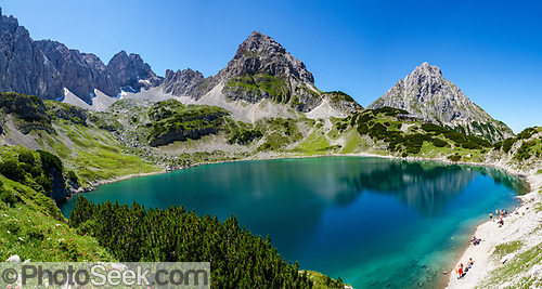
B.1 Lago Sorapiss trail (Belluno Province)
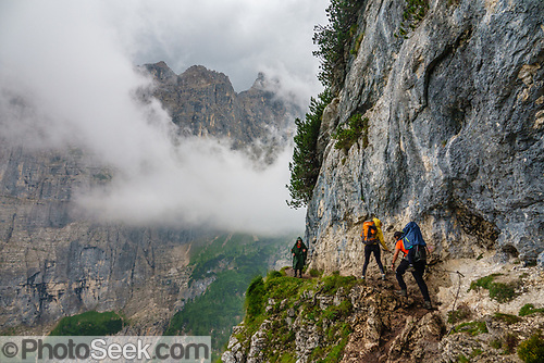
July 24, above and below: On the moderate trail to the lake of Lago Sorapiss, people with fear of heights may be concerned by several narrow ledges along cliffs, which others like me find exciting. Fixed wires are installed to grab for security. Start this hike early in the morning to avoid crowded backups where the exposed trail narrows. Hike to Lago Sorapiss and Rifugio Vandelli from B&B Hotel Passo Tre Croci Cortina on SR48 (7 miles round trip with 1350 feet gain) in the Sorapiss Range of the Dolomites, Belluno province, Italy. The trailhead parking is along the highway SR48 and in a free gravel lot just west below B&B Hotel Passo Tre Croci Cortina (whose own lot requires a displayed pass and is for guests only).

B.2 Cadini di Misurina loop (Belluno Province)

Above: Lake Misurina, largest alpine lake in the Dolomites, is beautiful at sunrise, in the headwaters of Auronzo di Cadore municipality.

July 25, above: Starting from Lago d’Antorno Trailhead, I hiked the impressive Cadini di Misurina loop trail for 5 miles in late afternoon. The 3 peaks of Tre Cime di Lavaredo rose out of clouds, but soon disappeared in a thunderous hail storm as I sheltered under an overhanging rock. Pea-sized hail accumulated then melted fast. After an 1850-foot ascent in the Cadini di Misurina Group, the Rifugio Savio (pictured) provides a restaurant and dormitories – but I hastened downwards in the rain to catch a hot shower and dinner prearranged at my hotel.
B.3 Croda da Lago loop (Belluno Province)

July 26, above: Croda da Lago loop trail has an easy first half to Lake Federa then a rough rock-hopping finish, in the Croda da Lago-Formin-Cernera group of Dolomites. The loop of 8.2 miles with 2800 feet gain and loss starts from the trailhead at “Ponte de Ru Curto” below Passo di Giau, above Cortina d’Ampezzo, in Belluno province, Italy. The easier walk to Lago Federa alone is 5 miles round trip with 1650 feet gain.
Below: See Cortina d’Ampezzo town from Forcella Ambrizzola pass, easily reached from Lago Federa along the Croda da Lago loop.

Below: Alpenrose (Rhododendron ferrugineum) blooms reddish-pink north of the steep and rough Forcella de Formin pass, along Giro Croda da Lago trail:

B.4 Hike Fiscalina Valley in Naturpark Drei Zinnen (South Tyrol Province)
Italy’s South Tyrol province is also known as Alto Adige, or the Autonomous Province of Bolzano. Place names in South Tyrol reflect the World War I stalemate between German-speaking Austria-Hungary and Italian-speaking Italy — plus Ladin is the third official language. Ladin speakers are just 4.5% of the population of South Tyrol. How did this mix happen? Entering the Dolomites more than 2000 years ago, the conquering Roman soldiers and employees brought “vulgar” Latin — the informal nonclassical Latin of ancient Rome, including the everyday speech of both plebeians and elites. Vulgar Latin combined with the native Rhaetian and Noric languages of the Dolomites to create Ladin, later influenced by German, then Italian.

July 27, above: Just 50 minutes drive from Cortina, a loop hike in Fiscalina Valley starts with grand scenery, shown here at Bistro Bergsteiger in Italy’s Sexten (Sesto) Dolomites, near Innichen (San Candido). I day-hiked 11.6 miles with 3900 feet gain and descent.
Directions to hike Val Fiscalina: Park in the pay lot at Hotel Dolomitenhof, near Moso, Italy. Hike to Zsigmondyhütte (Rifugio Zsigmondy-Comici), then to Dreizinnenhütte (Rifugio Locatelli alle Tre Cime) in Naturpark Drei Zinnen (Parco Naturale Tre Cime), then complete the lollipop loop downwards via the north side of the Lakes of Piani (Bödenseen / Laghi dei Piani) in the Sexten (Sesto) Dolomites Group, in South Tyrol province.
Below: Hikers admire the peak (on right) of Zwölferkofel (Croda dei Toni) on the way to Zsigmondy Hütte (Rifugio Comici).


Above: Continuing the Val Fiscalina loop hike reaches Dreizinnenhütte (Rifugio Locatelli alle Tre Cime). This refuge understandably attracts hundreds of daily hikers, who come mostly from Rifugio Auronzo’s large parking lot (which can fill by 9:00am, atop a toll road near Lake Misurina) via an easier loop of 5.5 miles with 1400 feet gain. Time allowing, do one or both spectacular loops (as I have on different trips). On the left is the peak of Paternkofel (Monte Paterno, 9003 ft). On the right are distinctive icons of the Alps known as Tre Cime di Lavaredo (Italian for “Three Peaks of Lavaredo,” also called Drei Zinnen or “Three Merlons” in German). Until 1919 the peaks formed part of the border between Italy and Austria. Now they lie on the border between the Italian provinces of South Tyrol and Belluno and still are a part of the linguistic boundary between German-speaking and Italian-speaking majorities. Cima Grande rises to 2999 meters (9839 feet), between Cima Piccola 2857 m (9373 ft) and Cima Ovest or “Western Peak” 2973 m (9754 ft).
Below: The Upper two Lakes of Piani (Bödenseen / Laghi dei Piani) lie under the peak of Paternkofel (Monte Paterno).

B.5 Lagazuoi Refuge (Belluno Province)

July 28, above: After vigorous hikes for five days in a row, my sixth day in the Dolomites was an easy cable car ride to see the impressive outlook from Lagazuoi Refuge, in the Ampezzo Dolomites above Falzarego Pass, halfway between Cortina d’Ampezzo and the Badia Valley. From the Refuge, one can walk 2.5 miles one way down 2200 feet on steep trails, optionally via dark slippery tunnels built in World War I (bring a flashlight).
Below: Riding the Rifugio Lagazuoi Funivia (cable car) reaches a scenic panorama of the Dolomites, improved by walking a wide family-friendly path to Piccolo Lagazuoi viewpoint shown here (0.8 miles round trip with 400 feet gain).


Map 3 of 4: Waypoints include: Innsbruck > Cable Car Lagazuoi at Passo Falzarego > Trailhead giro Croda da lago > B&B Hotel Passo Tre Croci Cortina > Chalet Lago Antorno trailhead for Croda da Lago Circuit > Hotel Dolomitenhof trailhead for the Fiscalina Valley loop > Heiligenblut classic view of Grossglockner peak > Kaiser Franz Josefs Höhe viewpoint > Edelweißspitze viewpoint in Hohe Tauern National Park
Part C: Austria’s Tyrol > Germany’s Bavaria
July 29: I drove back into Austria and across the spine of the Alps via Grossglockner High Alpine Road. The south end of that toll road is Heiligenblut village in the state of Carinthia, and north end is Bruck in the state of Salzburg.
Below: Behind the St. Vincent Pilgrimage Church, built in 1491 in Heiligenblut am Grossglockner village, rises glacier-clad Grossglockner — Austria’s highest peak (3798 meters or 12,461 feet above the Adriatic). It’s part of the High Tauern range within the Central Eastern Alps.


Above and below: On a branch of the Grossglockner High Alpine Road, Kaiser Franz Josefs Höhe lookout provides a massive free parking garage to visit the Pasterze, Austria’s biggest glacier, whose remarkably fast retreat has left a moraine moonscape (below), in Hohe Tauern (“High Mountain Pass”) National Park:

Below: Driving north from Kaiser Franz Josefs Höhe, you traverse the Hochtor Tunnel (2504m / 8215ft), on the border of the Austrian states of Carinthia and Salzburg. Built 1933–1935, the Hochtor Tunnel is 311m (340yds) long. Just south of the tunnel, a steep cobbled branch road leads to Edelweißspitze (2571m), the highest passable point of the Grossglockner High Alpine Road (Großglockner Hochalpenstraße), whose switchbacks wind through Hohe Tauern National Park:


Above: This tarn outlook at Weißsee Glacier World tactfully excludes the area’s dominating ski infrastructure, in Hohe Tauern National Park, state of Salzburg, Austria. Lack of snow in the Alps has left Weißsee Glacier World with shrunken glaciers and low reservoirs.
Directions to Weißsee: from Uttendorf, follow the toll-free road 16 km through Stubachtal to Enzingerboden valley station of the cable car. Take 6-seater gondolas to middle station Grünsee (1,740 m) (closed in 2023, requiring walking up 850 feet, 2 miles round trip) then ride the second stage gondolas to mountain station Berghotel Rudolfshütte at Weißsee (2,300 m). Trees felled by a recent windstorm disabled the lower lift, so I hiked to reach the upper cable car ride. Adding an extra 3 hours, hiking up Medelzkopf peak would have been worthwhile (4.2 miles round trip with 1740 ft gain from Rudolfshütte).
July 29, Saturday: Reaching lodging at inexpensive Pension Oberbräu in Mittersill, Austria, was unexpectedly blocked by festival barricades. On foot, I found the way to later drive through the little maze of celebrations, which honored wholesome small-town values such as carnival rides, children, bands, beer, and schnitzel.

July 31, above: The Gschlöss Valley (Gschlößtal) offers a scenic tractor taxi to reach Innergschlöß, in Hohe Tauern National Park, Austria. I hopped onto the quicker van taxi. The rewarding Gletscherweg Innergschloss loop trail ascends from beautiful Gschlöß Valley to closely view the rapidly-melting Schlaten Glacier (Schlatenkees) in the Venediger Group of mountains.
Directions to hike Gschlöss Valley, Austria: From Mittersill, drive 30 minutes south. Take the long tunnel (€13 toll each way) on FelbertauernStrasse mountain road B108, exit sharply right, then park in the pay lot at Matreier Tauernhaus. The Gletscherweg Innergschloss circuit is 6 miles with 2400 feet gain if using the taxi round trip from Matreier Tauernhaus to Innergschlöß, or else 12 miles & 3600 feet gain from Matreier Tauernhaus parking lot. In July 2023, the Innergschlöß taxis were €6 per person, every 20 minutes from 8:20am–5pm, either by fast van or slow tractor-pulled trailer, to reach Alpengasthof Venedigerhaus in Innergschlöß. At the loop’s high point, optionally add Neue Prager Hut, 3.2 mi with 1850 ft gain (making 9.2 mi round trip with 3850 ft gain, with taxi). If you have an extra day, hike from Innergschlöß along the Ochsnerwaldweg trail, on the mid level north side of Gschloss Valley (4 mi with 1100 ft gain round trip).
Below: A black sheep ewe minds her lambs above the Gschlöß Valley:


Above: Beautifully striated rock patterns are exposed along Schlatenbach stream. Melting like mad, on August 22, 2023 (CNN link) the Schlaten Glacier revealed the body of a climber who died 20+ years ago.
Below: Schlaten Glacier reflects in a pond along the Gletscherweg Innergschloss trail:

Salzburg, Austria
made a great rainy-day break from hiking on August 1. Salzburg is the fourth-largest city in Austria and is renowned for its Baroque architecture in one of the best-preserved city centers north of the Alps. The town is on the site of the Roman settlement of Iuvavum. Salzburg was founded as an episcopal see in 696 and became a seat of the archbishop in 798. Its main sources of income were salt extraction, trade, and gold mining. The fortress of Hohensalzburg, one of the largest medieval fortresses in Europe, dates from the 11th century. In 1600s, Salzburg became a center of the Counter-Reformation, with monasteries and numerous Baroque churches built. Salzburg’s Altstadt, or old town, is honored by UNESCO as a World Heritage Site. Busy Altstadt centers on Getreidegasse, a narrow, pedestrian street including Mozart’s Birthplace and shops selling folk costumes and antiques.
Below: Hohensalzburg Fortress dominates Saltzburg, such as seen here from Mirabell Palace Gardens, a setting for “The Sound of Music” film (1965), based on the 1959 stage musical.

Salzburg’s DomQuartier tour
Below: Residence Square (Residenzplatz) and Fountain in Salzburg’s Altstadt, or old town.

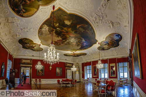
Above: With one ticket, Salzburg’s DomQuartier tour covers 1300 years of Salzburg rulership history, art, music and architecture including: the Audience Hall and Residenz of former prince-archbishops; the Terrace of the cathedral arch; the Northern Oratorio, the west gallery and organ loft in Salzburg Cathedral; the Cathedral Museum; the Cabinet of Art and Curiosities; the Long Gallery built 1657 – 1661; and the Museum of St. Peter’s Abbey.
Below: Rebuilt in Baroque style in the 1600s, Salzburg Cathedral and Museum is mind-bogglingly lavish. Mozart was baptized here.

Mozart’s Birthplace Museum / Mozarts Geburtshaus
The prolific Classical music composer Wolfgang Amadeus Mozart lived 1756–1791. Since 1880, Mozart’s Birthplace has exhibited the composer’s early life at Hagenauer Haus (No. 9 Getreidegasse) in Salzburg. Mozarts Geburtshaus makes a wonderful pilgrimage site for Mozart fans and history buffs, like me. I could feel the music in the humble walls — here’s the kitchen:


Above: Wolfgang Amadeus Mozart is portrayed in an 1859 oil painting idealized by Leopold Bode, based on the portrait Mozart in Verona by Giambettino Cignaroll from January 1770, which would make him no older than 14.
Below: “Mozart at the spinet,” oil painting by Anton Romako in 1877, used for decoration of the Magic Flute Summer-House.

Below: Mozart’s wife — Constanze Mozart (née Weber, 1762-1842) — is portrayed in this oil painting by Hans Hansen in Vienna in 1802 (11 years after Wolfgang died). Maria Constanze Cäcilia Josepha Johanna Aloysia Mozart was a trained Austrian singer. She and Mozart had six children: Karl Thomas Mozart, Franz Xaver Wolfgang Mozart, and four others who died in infancy. She was married twice, first to Wolfgang Amadeus Mozart; then to Georg Nikolaus von Nissen. She became Mozart’s biographer jointly with her second husband.

Eisriesenwelt ice cave
is the most significant cave system in the Alps. Claimed to be the world’s largest ice cave (42 km long), Eisriesenwelt (“World of the Ice Giants”) is actually a limestone cave containing ice decorations, mostly extensively in the first kilometer. This cavern makes an ideal activity for a rainy day. The main entrance lies high in the Tennen Gebirge mountains at 1641m elevation — an impressive 1000 meters above Werfen village in the Salzach Valley, in the state of Salzburg. Visiting the cave requires advance reservations, parking high on mountain road, walking up 20 minutes to a cable car, walking 20 more minutes up to the cave entrance, then walking 70 minutes up and down on the guided tour. Inside, about every fifth person carries a traditional carbide lamp with an open flame. The carbonate strata in this part of the Alps extends from the Triassic to the Jurassic, and the caves were formed during the late Tertiary period.

August 1, above: Visitors ascend the topmost mountain footpath to reach the mouth of Eisriesenwelt.
Below: People gather at the cavern’s entrance.


Above: Impressive ice formations grow inside Eisriesenwelt. Because the cave has no electricity installed, guides burn magnesium for temporarily brighter lighting.
Below: The medieval Hohenwerfen Fortress overlooks Werfen, a market town in Salzach Valley (40 kilometers south of Salzburg city), in the Sankt Johann im Pongau District of Salzburg state. The castle appeared in “The Sound of Music” film (1965), beyond the meadow of Gschwandtanger where Maria Trapp (played by Julie Andrews) taught the children the famous “Do Re Mi” song — you can walk to where they picnicked via The Sound of Music Trail. The castle was the main location in the 1968 film “Where Eagles Dare” starring Richard Burton, Clint Eastwood and Mary Ure. Hohenwerfen was built in association with Hohensalzburg Fortress in 1075–1078 at the behest of Archbishop Gebhard of Salzburg during the Imperial Investiture Controversy, meant as a strategic bulwark atop a 155-meter (509-ft) high rock. The route up to Eisriesenwelt ice cave offers several vantage points to see the castle from above.

Berchtesgaden in Bavaria, Germany

Above: The Catholic Parish Church of St. Sebastian, built in 1512, makes an impressive photo op in Ramsau bei Berchtesgaden, near Berchtesgaden, in southeast Germany.
Aug 2, below: Kehlsteinhaus (external link), known in English-speaking countries as Hitler’s Eagle’s Nest, was built by the Nazis in 1938 atop the rocky outcrop of Kehlstein (1,834 m or 6,017 ft), which rises above Obersalzberg, near Berchtesgaden, in Bavaria state. Kehlsteinhaus was used exclusively by members of the Nazi Party and was visited 14 times by Adolf Hitler. Today, it is open seasonally as a restaurant, beer garden, and popular site of international tourism. This view by telephoto is from Jenner Observation Platform, described below.


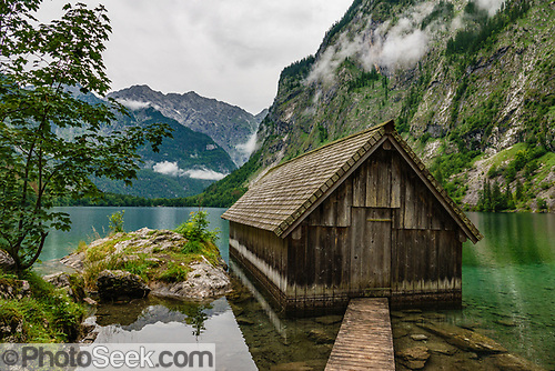
Aug 2, above: Jenner Observation Platform gives a birds-eye view of fjord-like Königssee (King’s Lake) and the villages of Schönau and Berchtesgaden, in Germany. The Jennerbahn cable car ascends to Jenner Alm, where a walk of 1 km round trip with 75 meters gain leads to Jenner Observation Platform. To best enjoy the pristine lake with fewer crowds, take the earliest Königssee boat tour in the morning (8:00 am in July), then ride the Jennerbahn, which has the same parking lot in Schönau am Königssee village.

Aug 2, above: The iconic St. Bartholomew’s Church was built in 1697 on Königssee (King’s Lake) near Berchtesgaden. In peak tourist season, don’t disembark at the Church, due to possible hours-long reboarding queues. Instead, continue to the last stop at Salet, where easy walking 1–5 miles round trip experiences beautiful Obersee Lake and Röthbach waterfall (470 meters), highest in Germany. Berchtesgaden National Park is honored by UNESCO as Berchtesgadener Land Biosphere Reserve.

Above and below: The furthest boat landing on Königssee is Salet.


Above: From Salet landing, follow an easy trail for 1 mile to the pretty lake of Obersee, where you can admire a nearby boathouse and the distant Röthbach Waterfall, highest in Germany. The above view of Obersee is about 1.6 miles from Salet.
Below: The blue-green waters of Obersee reflect cliffs in Berchtesgaden National Park.

August 3, 2023: Tom flew home from Munich to Seattle.
Map 4 of 4: Waypoints include: Parkhaus Kaiser Franz Josefs Höhe on Grossglockner High Alpine Road in Austria > Edelweißspitze viewpoint > Weißsee Glacier World > Matreier Tauernhaus trailhead for Gschlöss Valley > Parish Church of St. Sebastian in Ramsau, Germany > Königssee boat tour near Berchtesgaden > Eisriesenwelt Trailhead, Austria > Mozart’s Birthplace in Salzburg > Europcar Car Rental at Munich Airport, Germany
Travel tips for Munich: Advance planning made the 3-week journey sail smoothly! Flying on Icelandair from SeaTac Airport in Seattle via Keflavik to Munich takes 7.5 hours, plus 1 hour plane change to stretch the legs and enter Europe customs, plus a final 3.5 hours. Not bad. I found the best car rental deal at AutoEurope.com (external link), which was serviced in Munich by Europcar — where rental checkout will be quicker if you stick to your booked car and cut short their upgrade/change spiel. Double check whether your car uses Benzin (gasoline) or Diesel (with much pricier car rate although cheaper fuel). I insisted on using my credit card’s CDW coverage (which required a temporary $3000 held on the card), instead of paying extra for their coverage. Allow at least an extra hour to navigate through heavy traffic in Munich or Innsbruck. After some initial circling, dropouts in the cellphone signal, and heavy commuter traffic around Munich, I zipped down the super smooth Autobahn, bought the required toll vignette hologram sticker for Austria at a gas station, and arrived at a nice apartment in Ehrwald, Austria, reserved weeks earlier on Booking.com.
Google Maps tips: Downloading local Google Maps in advance is essential for streamlined navigation — independent of possibly-unreliable cell signal. Save GPS waypoints for sights and trailheads in your Google Maps account before departure. While connected to Wi-Fi using the Google Maps app, from your account icon, select Offline Maps. Download the areas that you’ll be visiting, overlapping as needed, in blocks measuring up to 250 by 150 miles each. Google allows storing up to about 10 separate maps on each device. While Downloading, immediately rename each block by describing the region. Downloads expire in 1 year, but you should Update each using Wi-Fi right before the trip (to ensure that all of your latest waypoints Saved in your online Google account, plus road updates, are recorded onto your device/phone).
Gaia GPS app: is essential for tracking your mountain hikes or city walks on a topo map. Never get lost again. Join Gaia for a small yearly fee in order to Download each country in advance, for essential offline use (since mountains hikes usually don’t have a cell signal). Optionally load GPX tracks of your routes in advance, obtained from the Gaia website or other sources, or simply “Create a Route” in the Gaia app. (Membership in the AllTrails app is almost as good.)
Language was more of a barrier than I expected in small towns of Austria and Italy, exacerbated by my shyness and being afraid of making a mistake. (My French and Spanish knowledge was of little use!) To meet people, I gave rides to two couples in need. By the end of the trip, my German and Italian language basics were improved by real-world practice.
Recommended online guides (external links)
- Moon & Honey Travel: excellent source for identifying hiking priorities
- EarthTrekkers.com: one of my favorite online hiking guides
- Austria & Germany travel & hiking guides
- 15 Epic Hikes in the Dolomites Ranked
- Tyrol.com — a wealth of local tips for the Austrian state of Tyrol (Tirol in German)
Recommended guidebooks
Alps hiking books by Cicerone Guides are essential for planning a hiking trip and carrying along:
- Day Walks in the Dolomites: 50 short walks and all-day hikes in the Italian Dolomites (Cicerone Guides) Paperback – 2023, by Gillian Price, encourages hiking combined with public transportation
- 100 Hut Walks in the Alps: Routes for day and multi-day walks (Cicerone Guides) Paperback – August 30, 2014
Search for the latest Austria guidebooks on Amazon.com.
Search for latest “Italy travel books” on Amazon.com (look for updates every 1 to 3 years). Bring good country and city guides on the trip. Hikers and trekkers should add a walking guidebook. Get the latest ebook versions, which are searchable and lighter-weight than printed books (for smartphone, Kindle, tablet, and PC).
- DK Eyewitness Italy (Travel Guide) Paperback – June 22, 2021: helped me quickly plan and prioritize a meaningful trip to Venice, the Veneto, and Dolomites.
- Lonely Planet Italy 16 (Travel Guide) Paperback – 2023: covers the country in great detail
- Rick Steves Italy (Travel Guide), Paperback with Folded Map: defines concise and efficient tour itineraries for those with limited time. Rick Steves updates the books every year for each country in Europe, saving time and money on heartfelt experiences.
- Rick Steves Venice (Travel Guide): updated yearly
- Explore Europe on Foot: Your Complete Guide to Planning a Cultural Hiking Adventure by Cassandra Overby – Paperback – 2018: highly recommended by Tom for both inspiration and practical details for planning your next walking adventure